what are your favorite maps for osmand and other map apps?
There are a lot of online maps. What do you use? What’s your favorite? Is one funny/ strange?
This magazine is from a federated server and may be incomplete. Browse more on the original instance.
There are a lot of online maps. What do you use? What’s your favorite? Is one funny/ strange?
My biggest wish is that there’s an easy way to contribute images to wikimedia and to link them easily with osm. As soon as that’s possible, we’ll map the world much quicker and more reliable. Someone might take pictures of benches and another one will add the info if there’s a backrest from home.
The German chapter of OpenStreetMap, FOSSGIS e.V., has voted unanimously to a commitment providing annual financial support to the OpenStreetMap foundation. This is a first-of-its-kind decision for an OpenStreetMap local chapter, reflective of the German OSM community’s relatively large size and financial resources, as well as...
In the web UI, OSM can’t be zoomed in far enough to see the names of POIs in reasonably dense areas. I can get around this by going into edit mode, and mobile apps don’t have this restriction. But the out-of-the-box experience, for non-insiders just using the web site, doesn’t reveal all that OSM has to offer....
from: isnichwahr.de/r426689-verruecktes-china-vvs.html...
This and more changes in Carto Style v5.8.0...
things experienced by me:...
The longest current OpenStreetMap username is “bwdlqwbdjlbqlwdjbqlwjdbqljwbdlqwjbdlqwjdblqjwbdlqjwdbqlwjdblqwdblqjbdlqjwbdljqbwdljqwbdlqbwdbqwdblqwdlqwbdlbdlqbwldbqlwbdlqbwdlqbdlqbdljwbdlqwbdwlbqlwdblqwbdjlqwbdjlqwbdljqwbdljqbwdljqbdlqwbdlqbdljqbdljqbwdljbqldbqlwdbljqwbdljqwdbqlwdbqlwjdbqlwdbqlw”.
I’m trying to tag a new bus route (which includes new stops) but I’m not sure which option is best. Looking at some of the current stops, there are multiple of them which have been tagged slightly different (see examples below)....

i’m on mostly on android so excuse my unfamiliarity....
Summary of the video (generated by Kagi):...

I did not yet fully understand this proposal in its current state, since there are lot of different possibilities to tag sidewalks, footpathes etc....
How many of them did you create?
Does anyone know why the Humanitarian OSM Team’s (HOT) old 2014 project to map Gaza has been archived, and no new ones have been opened in recent weeks?...
hello!...
Is there a way to overlay property lot lines (aka land ownership maps) on the map of preferably a mobile FOSS application? I like OSM And and I know there are ways to make certain obscure things work. OnX Hunt has this feature but I don’t want to use the application
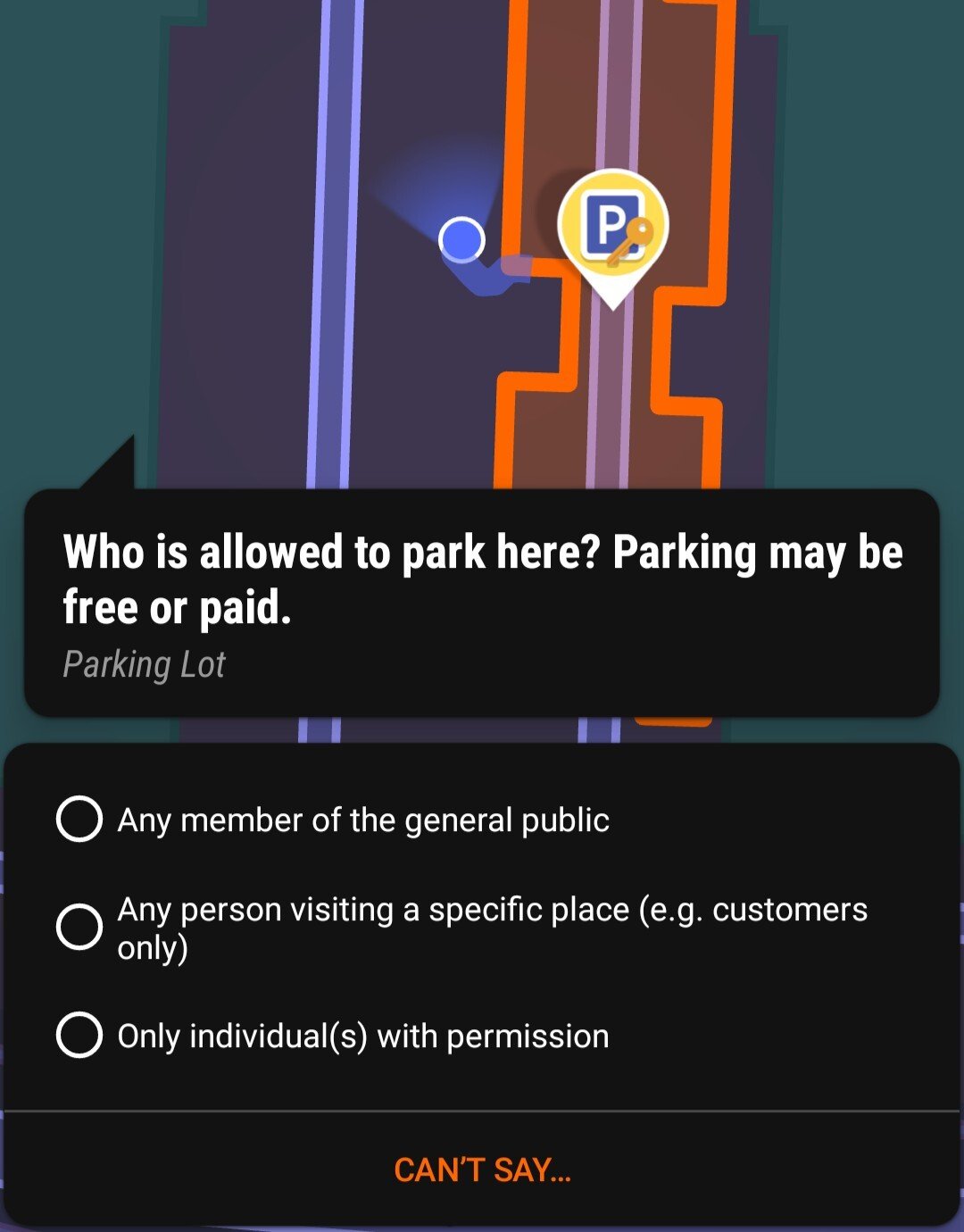
I was out walking around and “popping” quests on StreetComplete. I was wondering what the consensus is on the question “Who is allowed to park here?” In this case, it’s an ungated parking lot next to a commercial/industrial warehouse with many companies occupying the same space. A few of the parking spots had a sign...

How many of them did you create?

It seems pretty clear that street-level imaging on OSM is pretty lacking, unless you only want to see highways....
on a block of downtown san francisco, there are two block-long lines labelled ‘address interpolation’. there aren’t many nodes along this block, but the ones that exist mostly have explicit addresses assigned....