anarchist,
@anarchist@lemmy.ml avatar

Why use Mercator?

edgemaster72,
@edgemaster72@lemmy.world avatar

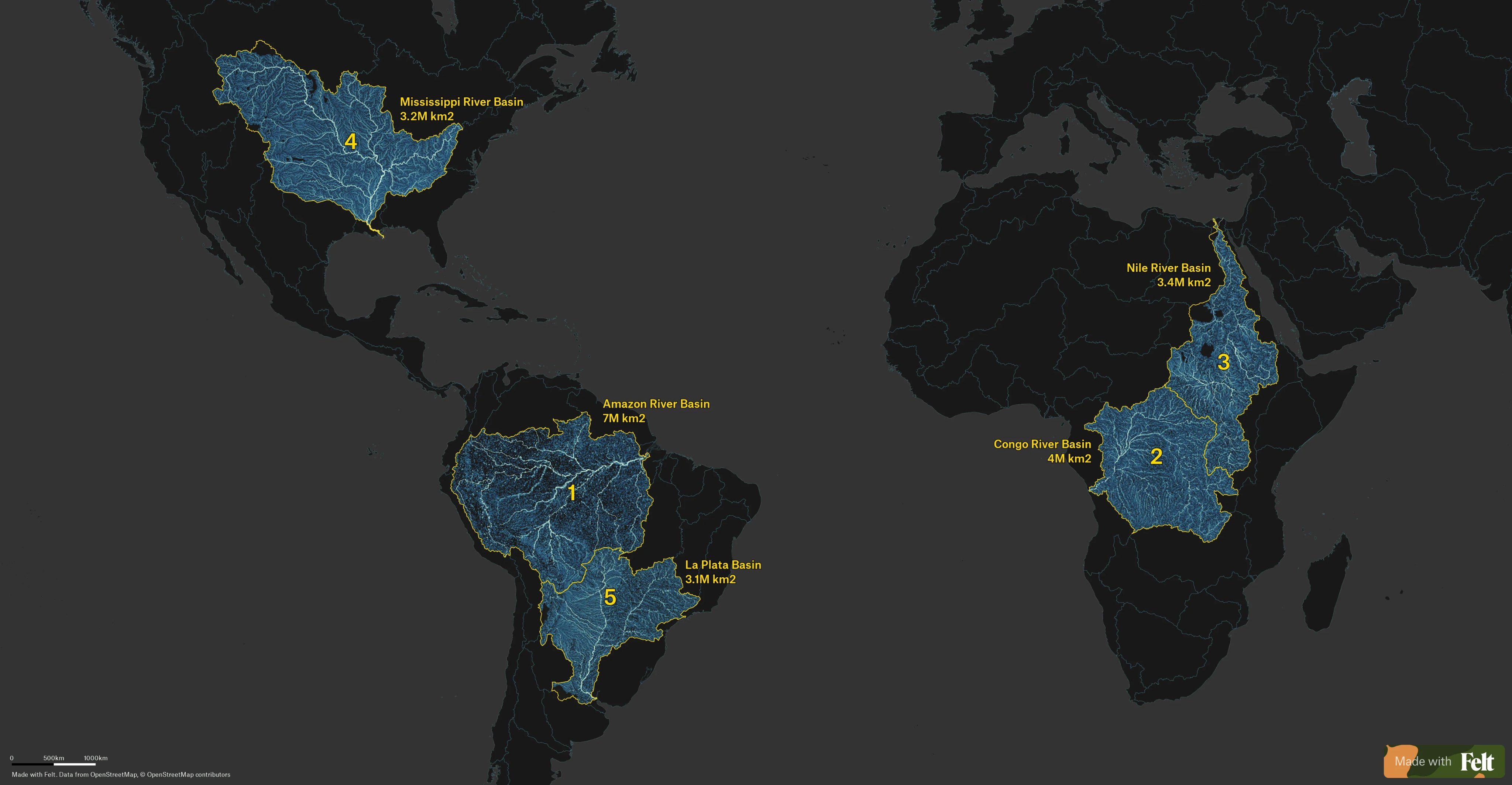
If you tilt your head to the right the Amazon one looks like a lightning strike with various branches. Probably could be said of all of them but I think that one is the best example.

niktemadur,

The Nile basin extends much further south of Lakes Victoria and Tanganyika than I would have imagined.

ichmagrum,

Rhine river basin looks a lot bigger than I remember.

SubArcticTundra,
@SubArcticTundra@lemmy.ml avatar

Does Antarctica have any ‘rivers’? Or does all the snow just stay there

gedaliyah,
@gedaliyah@lemmy.world avatar

Username checks out

Not_mikey,

The glaciers and ice flow down to the ocean, here you can see the velocity of the ice there are a couple red streaks that could be called streams but they aren’t the long narrow fast moving streams we’d call a river.

Zagorath,
@Zagorath@aussie.zone avatar

This is fascinating to see pictured!

I’d love to see a version expanded to the top 10.

bionicjoey,

Yeah I’d love to see more. The major rivers of China as well as the Niger and St. Lawrence would be awesome.

bort,
captainlezbian,

Oh jeez Europe only has one significant one and it does not cover as much as expected.

Gray,
@Gray@lemmy.ca avatar

It’s wild how close the Amazon river basin comes to the west coast of the continent without draining into the ocean on that side.

WarmSoda,

Well, there’s a little bunch of hills over there blocking it.

Pantrygheist,

The Andes blocking all the good stuff from going into Peru, Bolivia and Chile

gedaliyah,
@gedaliyah@lemmy.world avatar

I read somewhere that the Amazon River used to run from east to west until about 6 million years ago when the Andes Mountains developed, reversing the course

bort,

eurasia, are you even trying?

drolex,

Mountains not conveniently arranged along the edges of the continent 😤. Who designed this shit?

geogle,
@geogle@lemmy.world avatar

Plate tectonics. Blame PT.

infeeeee,

It depends on how you define a river. This map displays Rio de la Plata as a river, but that’s debateable, officially it’s an estuary. If you separate Parana and Uruguay rivers, than the Ob river basin in Asia is bigger than any of those.

en.wikipedia.org/…/List_of_drainage_basins_by_are…

Jerb322,
@Jerb322@lemmy.world avatar

Sorry, I’m not familiar, what is the measurement M km2?

nezbyte,

Million kilometers squared

drolex,

1Mkm² ≈ 33 Belgiums ≈ 247M football pitches ≈ 1549806949806949 sq. in

jaybone,

How many bananas is that?

KnightontheSun,

At least seven.

  • All
  • Subscribed
  • Moderated
  • Favorites
  • map_enthusiasts@sopuli.xyz
  • DreamBathrooms
  • magazineikmin
  • ethstaker
  • GTA5RPClips
  • InstantRegret
  • rosin
  • love
  • Youngstown
  • slotface
  • khanakhh
  • kavyap
  • everett
  • thenastyranch
  • osvaldo12
  • provamag3
  • tester
  • cisconetworking
  • tacticalgear
  • ngwrru68w68
  • Durango
  • cubers
  • mdbf
  • normalnudes
  • anitta
  • modclub
  • Leos
  • megavids
  • JUstTest
  • All magazines