@robinlovelace@fosstodon.org
@robinlovelace@fosstodon.org avatar

robinlovelace

@robinlovelace@fosstodon.org

Data science, transport modelling and geocomputation for evidence-based policy, transport decarbonisation and enlightenment.
searchable

This profile is from a federated server and may be incomplete. Browse more on the original instance.

robinlovelace, to datascience
@robinlovelace@fosstodon.org avatar

Request for testing/comment: can any users out there give the {styler.equals} package a spin and kick its metaphorical tires 🚲 ? Install with remotes::install_github("robinlovelace/styler.equals") and see more at https://github.com/Robinlovelace/styler.equals Especially for those who prefer typing = over <- due to laziness or any other reason! Not intending to start a flame war 🔥 arrows are great too ⬅️ Any comments/suggestions welcome 🙏

robinlovelace, to random
@robinlovelace@fosstodon.org avatar

So many rewarding things about building in the open. One of the biggest is the sense of "Wow I did it" you feel when new contributors get involved. I remember the first time I contributed to an open source project and it felt amazing, built by the community, for the community.

robinlovelace, (edited ) to foss
@robinlovelace@fosstodon.org avatar

Request for help from anyone with package development experience or knowledge of time data, especially if you've worked with .ical files before: checks failing in the {calendar} package preventing updated on CRAN and I'm not sure why 🤷 . Thanks to new contributors for reviving this package after ~5 years dev hiatus! Please spread the word @rOpenSci and anyone in this for (or at least dates) space! Details: https://github.com/ATFutures/calendar/issues/50

robinlovelace,
@robinlovelace@fosstodon.org avatar

@_TimTaylor @rOpenSci shouldn't be a timezone issue becuase it's Zulu time in the golden file. More details in the issue..

robinlovelace, to rust
@robinlovelace@fosstodon.org avatar

Excited to announce the release of {stplanr} v1.2.0, on CRAN and beyond 🎉
Key feature: new implementation of rnet_join(), allowing fast+flexible merging of route network datasets, leveraging {rsgeo} which has a fast (~1000x faster than {lwgeom}) backend 🔥

robinlovelace,
@robinlovelace@fosstodon.org avatar

Many people to thank for this release 🙏
It's been almost 8 years since {stplanr} v0.01 was released to support tools for planning. The first major use case was the Propensity to Cycle Tool 🚲 now publicly available at https://pct.bike

robinlovelace, (edited )
@robinlovelace@fosstodon.org avatar

Special thanks to @josi for upstream work on {rsgeo} to support fast line splitting, needed for accurate joining of disparate linestrings. Work still underway on this, watch this space 🏗️ https://rsgeo.josiahparry.com

robinlovelace,
@robinlovelace@fosstodon.org avatar

In fact, {stplanr} is the first package to build on {rsgeo} of packages in the main package repository. Won't be the last I suspect (and nudge re releasing a new version Josiah ; ) https://cran.r-project.org/package=rsgeo

robinlovelace,
@robinlovelace@fosstodon.org avatar

How to get it and give it a spin? The following command should do it if you have R installed:

install.package("stplanr")

For more details see the package's website and link to the code on GitHub, feedback + contributions welcome 🙏 https://docs.ropensci.org/stplanr/reference/rnet_join.html

robinlovelace, to random
@robinlovelace@fosstodon.org avatar

I'll be presenting on the Cycle Route Uptake and Scenario Estimation (CRUSE) tool for Ireland at the the TRA conference this afternoon, 17:45 session. If you cannot make it in person, you can give it a spin here: https://cruse.bike/

robinlovelace, to random
@robinlovelace@fosstodon.org avatar

Just updated the 3-way-classification of cycle infrastructure (not paint) for Leeds map. Anyone interested in this and with local knowledge, please take a look at interactive results, feedback very welcome (are any segments wrong/missing?): https://github.com/nptscot/osmactive/releases/download/v0.1/classify_cycle_infrastructure_leeds.html

robinlovelace, to random
@robinlovelace@fosstodon.org avatar

Experimenting 3-way classification of cycleways w. Sustrans Scotland. Simpler than many classifications, but effective? Feedback on this welcome (especially from people with local knowledge in Edinburgh)! Interactive version: https://github.com/nptscot/osmactive/releases/download/v0.1/cycle_network_classified_edinburgh.html

robinlovelace, to random
@robinlovelace@fosstodon.org avatar

Just delivered the 'networkmerge' talk at 2024 on behalf of the team 🙏 Great event, excellent questions and follow-up possibilities (for improving GPS data aggregation and pedestrian analysis), stoked to get this out there. Slides + code: https://buff.ly/43Y4KM1

robinlovelace, to random
@robinlovelace@fosstodon.org avatar

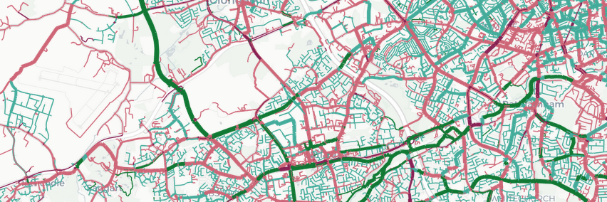
Building "protected" cycleways parallel to roads that save people from mixing with motor traffic is one thing. Building cycleways that are far from roads is quite another. Cycleways at least 10 m from roads in central Leeds below, we have a long way to go.

robinlovelace, to random
@robinlovelace@fosstodon.org avatar

This is one of the best descriptions of the benefits of switching from non-reproducible WYSIWYG (What You See Is What You Get ) writing software e.g. Word 📎 to reproducible plain text formats like LaTeX or better Quarto. Credit: Joel Schneider and his APA template https://buff.ly/3TRz0Uk

robinlovelace, to random
@robinlovelace@fosstodon.org avatar

This is very cool: new interactive map showing travel times to key destinations, and combinations of different destinations by mode. Simple yet powerful, and should be straightforward to reproduce in other places.

video/mp4

zverik, to random
@zverik@en.osm.town avatar

Did anybody by any chance run a city-wide project to inventorize cycling roads and lanes? Which tools were most useful for that?

(Planning to do that this year, and so not wanting to write everything from scratch)

robinlovelace,
@robinlovelace@fosstodon.org avatar

@underdarkGIS @zverik well stplanr is more general geo processing for transport planning. Can work with osm data. Do have more on this if interested, what tools/languages are you familiar with?

robinlovelace,
@robinlovelace@fosstodon.org avatar

@zverik @underdarkGIS ok great they're is a lot out there. Osmnx and a new od2net tool is good can send some pointers. What's your user case and what data do you have? Cc @mszll

robinlovelace, to random
@robinlovelace@fosstodon.org avatar

Update on the Network Generation Hackathon, mission accomplished. We all got od2net running, explored new ideas, and ported the setup script into a new language which can be found in this merged PR: https://buff.ly/48EAaI1 Massive thanks to everyone involved.

robinlovelace, to random
@robinlovelace@fosstodon.org avatar

Looking forward to the Network Generation Hackathon tomorrow in the Alan Turing Institute 🚀 For anyone interested in reproducible transport network generation, processing and modelling with open source software this could be of interest, still opportunities to attend online: https://buff.ly/3SUZSm3

robinlovelace, to datascience
@robinlovelace@fosstodon.org avatar

So true! For this reason the Transport Data Science module I lead focusses on applications, taking the initiative (you choose the topic you apply the science to and datasets), and empirical exploration. Written for early programmers but equally applicable now

robinlovelace, to datascience
@robinlovelace@fosstodon.org avatar

On Thursday I delivered the first session of our new and improved Transport Data Science course at Leeds Institute for Transport Studies (ITS) / Urban Data Science (UDS). For anyone interested in reproducible + open for transport: https://itsleeds.github.io/TDS/slides/1-intro.html

robinlovelace, to random
@robinlovelace@fosstodon.org avatar

Ever wanted to do spatial clustering of orign-destination (OD) data? Well you may want to now! University of Leeds Institute for Transport Studies (ITS) and Alan Turing Institute PhD student Hussein Mahfouz has created this early-stage visualisation of spatial clustering of these zone-zone flows 🏗️ Case study of . Looks beautiful AND useful 🎉

robinlovelace, to random
@robinlovelace@fosstodon.org avatar

Very happy to have submitted a paper to 2024 in my home city of . It was a collaborative effort by me, ITS Leeds colleague Zhao Wang, Will Deakin from Network Rail and Josiah Parry from Esri. All open and reproducible of course thanks to Quarto template by Steph De Sabbata: https://github.com/sdesabbata/quarto-gisruk Details: watch this space!

robinlovelace,
@robinlovelace@fosstodon.org avatar

@wnd 😸

EvaMaeRey, to random

I'm gonna follow in the 'one geo-viz in 31 days for the "Geocomputation with R" book cover' competition, with a personal goal, 366-day mapping package challenge for {ggnorthcarolina} & {ggnc} Goal is to make a stable template & helper package for ggplot2 sf extension. Would welcome for feedback from the Geocomputation with R community! @robinlovelace @nowosad https://github.com/EvaMaeRey/ggnorthcarolina Hope you've gotten outstanding submissions for book cover initiative & congrats on the book!

robinlovelace,
@robinlovelace@fosstodon.org avatar

@EvaMaeRey @nowosad @defuneste this sounds great!

  • All
  • Subscribed
  • Moderated
  • Favorites
  • Leos
  • thenastyranch
  • magazineikmin
  • tacticalgear
  • InstantRegret
  • ngwrru68w68
  • Durango
  • Youngstown
  • slotface
  • mdbf
  • rosin
  • PowerRangers
  • kavyap
  • DreamBathrooms
  • anitta
  • vwfavf
  • hgfsjryuu7
  • cisconetworking
  • osvaldo12
  • everett
  • ethstaker
  • GTA5RPClips
  • khanakhh
  • modclub
  • tester
  • cubers
  • normalnudes
  • provamag3
  • All magazines