Automatic Dependent Surveillance–Broadcast

ai6yr,

Hmm, HH-60 Pavehawk, JOLLY96 making an awful lot of noise tonight.

MsMerope,
@MsMerope@sfba.social avatar

@ai6yr

crews are ramping up for summer.

"Effective Wednesday, May 15, 2024 at 0800 hours ... [we] will transition into Wildland Fire Season. Dispatches for
wildland incidents will be enhanced to reflect in-season apparatus requirements based on specific zone threat levels."

Dozers and Air Ops are ramping up and getting checked off on their certs & quals for the season... there's been a lot of interagency trainings and what not going over the past few weeks.

ai6yr,

@MsMerope Well, that one is an Air Force rescue chopper, I think... that said, the MAFFS aircraft are EVERYWHERE this week.

Susan_Larson_TN,
@Susan_Larson_TN@mastodon.online avatar

I got a new outdoor antenna for my rig. It increased my range by over 100 nm.

My next step will be getting a Raspberry Pie so I can use FlightAware's PiAware system, which is going to run me around $150.00. I have to save up for it so it will be a month or so before I get it.

The reception from my Virtual Radar ADS-B display which shows a lot of aircraft data

Eka_FOOF_A,
@Eka_FOOF_A@spacey.space avatar

@Susan_Larson_TN
Cool.

I should get my system setup again. I live under the flight path for a runway. At least it is only a small airport, and it's short runway.

stfn,
@stfn@fosstodon.org avatar

Looks like the traffic above my head is growing. I am getting data from all those planes with my RTL-SDR and a DIY antenna

mikolasan,
@mikolasan@mastodon.social avatar

@stfn I see only one route that is not straight. Do they all just passing by?

stfn,
@stfn@fosstodon.org avatar

@mikolasan I have a typical problem of ground-based radars, I mostly see airplanes that are high in cruise altitude. Only the ones in the bottom right are low, as they are landing at the nearest airport

ai6yr,

POTUS in Ventura County (well.. Ventura County airspace, at least).

BakerRL75,
@BakerRL75@m.ai6yr.org avatar

@ai6yr Be interesting if he helicopters into SBA from San Francisco…

ai6yr,

USMC flight that crashed was TIGER11, AE4B95.

https://globe.adsb.fi/?icao=ae4b95

zl2tod,
@zl2tod@mastodon.online avatar
ai6yr,

@zl2tod Thanks.

ai6yr,

Hmm, wonder what this is all about.

ai6yr,

@BakerRL75 Unrelated exercise nearby IMHO.

BakerRL75,
@BakerRL75@m.ai6yr.org avatar

@ai6yr @BakerRL75 If I know my Marines only if they were given news…

ai6yr, (edited )

CNN: Taylor Swift's attorneys are threatening legal action against Florida college student @jxck_sweeney who posts publicly available flight tracking data from the superstar's private jet. https://www.cnn.com/2024/02/06/tech/taylor-swift-private-jet-tracker/index.html

rolandelli,
@rolandelli@sfba.social avatar

@ai6yr interesting, people do that here for Musk.

ai6yr,

@rolandelli Same source code for tracking any plane...

movingpandas,
@movingpandas@fosstodon.org avatar
stfn,
@stfn@fosstodon.org avatar

And I'm back to collecting aircraft positions using and FlightAware

firephoto,
@firephoto@mastodon.social avatar

@stfn I feed adsb.fi after the adsbexchange sell out.

Looks like maybe a low level gap in your area...

https://globe.adsb.fi/?icao=48c584

random plane that was in the area when I looked.

stfn,
@stfn@fosstodon.org avatar

@firephoto yeah, I have some low hills in front of me, so low flying aircraft hide behind them. And I only see maybe 150 degrees, from south west to north

ai6yr,

Hmm, quite the solar flare today, per the NOAA -- it appears aircraft radios were affected.

W6KME,
@W6KME@mastodon.radio avatar

@ai6yr But propagation overnight should be awesome, probably all the way up to 15m

weezmgk,
@weezmgk@mastodon.social avatar

@ai6yr sunfarts 😵

ai6yr,

Working on fixing up my plane bot code, but find this screen shot amusing (the wrong aerial map), but it says "PRISON"

ai6yr,

@volvodadfast Probably.

ai6yr,

@bbaugh @quakes This is a screen shot using Selenium. If I were you, however, I would use folium (if you are able to... python) I do this with @nwstornado_bot and @easwatch -- using something like this.

vk3xe,
@vk3xe@mastodon.hams.social avatar

I know there are plenty of folks here who are nerds but what about ? Are there open AIS networks like that have been built for capturing ADSB data?

ai6yr,

@vk3xe Yes, at least here in Southern California, where I am. Santa Barbara Amateur Radio Club (SBARC) has a combo ADSB/AIS reception location on a hill here. https://www.sbarc.org/ais-marinetraffic-system/

ai6yr,

Really should get this bot working normally... https://m.ai6yr.org/

ai6yr,

Detector definitely works, logic for posting (and screen shots) not.

pixel,
@pixel@social.pixels.pizza avatar

@ai6yr oh nice! - i thought you were doing it from the image 😊

ai6yr,

Ah, forgot about that bot. Now to see if I can revive it... possible flights circling in Los Angeles. Logic works, but screen shots do not seem to be.

Cvwarren,
@Cvwarren@mastodon.cloud avatar

@ai6yr any sign of Lemonodor on Mastodon that you’ve seen?

ai6yr,

@Cvwarren He's at @lemonodor -- but not sure how active he is here.

ai6yr,

20% off at the Flightaware store, for the ADSB/aviation geek crowd. Good prices on band pass filters and receivers, they typically are only during their Black Friday sales.

cetan,
@cetan@toot.community avatar

@ai6yr one of the cofounders of Flightaware is on Mastodon: @nugget :)

ai6yr,

Search grid for that missing (via TheIntelFrog)

petes_bread_eqn_xls,
@petes_bread_eqn_xls@mastodo.neoliber.al avatar

@ai6yr I assume the 6 is supposed to be a 9

WXFanatic,

Yesterday I created a ADS-B placefile script after I was generously provided a chance to use adsb.one's new API.

No icons yet, but it updates every 15 seconds and works fairly well!

Currently I only have placefiles for St. Louis and Tallahassee (250 mile radius). I don't wanna bog down the API as it seems relatively new and that community has been so kind to me in the past.

They're currently available, experimentally, here: https://placefiles.supercellwx.net/

video/mp4

ai6yr,

@WXFanatic Fun! (I should tap into that API for my circling planes bot... which I got distracted and stopped working on...) https://www.washingtonpost.com/climate-environment/2022/09/22/jetblue-hurricane-flight-fiona/

WXFanatic,

@ai6yr That's actually a great idea. That community has always been cool to me on Discord and I can't recommend them enough. I avoided it for a little while after ADSBx sold out (I don't handle drama well), but now things are so much more chill and I'm back to feeding again.

Have fun with it: https://github.com/ADSB-One/api/blob/main/README.md

I was tracking the hurricane hunters yesterday with the AllisonHouse placefile. Some questionable mb readings but still cool nonetheless lol

skykiss,
@skykiss@sfba.social avatar

Dear Xi,

We are watching you.

The Wing Loong-10 is a series of ChiCom unmanned aerial vehicles of the High-Altitude Long Endurance type, featuring some stealth characteristics. As of 2017, it is being developed by the Chengdu Aircraft Industry Group for reconnaissance and precision strike missions.

  1. Looks to have landed at Foshan (ZGFS)

  2. CAIG Wing Loong-10 UAV using callsign 00CA6181 and hex code passing over Hezhou

  3. Chi likes to fly it at 39,400 next to Taiwan. At that altitude, this platform had a complete view of the entire island of Taiwan for about an hour and a half. 1/2

image/png
image/png

mickmeally,

@skykiss Listed as a 'Private Owner' so nothing to see here! 😜 🇹🇼

Innocently whistling GIF

thebaldgeek,

Im testing out using an mini vs the v3 on my ADSB system.
I'm all that hard core on but its nice to corollate the testing I do with ADSB data.
As usual with aircraft data, it needs to soak for a week before you can really make any conclusions.

Was a bit surprised to see this Osprey V22 fly past on the map.

jbaggs,

@thebaldgeek Not that odd near Pendleton, is it?

thebaldgeek,

@jbaggs
I see and hear them more with the eyes and ears than they show up on ADSB, so I should have been clear what was a little odd...

jerseybastion,

The FOSS4G team has been posting this year's talks and mine just hit the channel: https://www.youtube.com/watch?v=gl7LMEPvAmo

A companion article is here: https://www.jaxartes.net/pages/ads-b/

ai6yr,

Fixed my receiver, hopefully- switched to a beefy AudioWind DC to DC regulator to go from 12V to 5V supply for the - prior converter seemed unreliable.

raymccarthy,
@raymccarthy@historians.social avatar

@ai6yr
I know worse.
Worse even than the micro-mini-coax plugs for laptop wifi cards.

Raspberry Pi to a wood board: The origin of Breadboard was screwing 4 pin sockets and parts to a real breadboard and then solid wires to assemble a kit radio in 1920s UK as a kit needed no GPO licence fee at first.

tomjennings,
@tomjennings@tldr.nettime.org avatar

@ai6yr

> microUSB connectors are
> the worse connector known
> to mankind

30 min later I can come up with no refutation.

Ok I'm sure there are "worse" but multiplied by the number of them we deal with ...

thebaldgeek,

Seeing a whole bunch of BA (and other) flights getting msg to turn around. Like. Right now.
6 hours into the flight?
Yeah, turn around.

image/png

mightyspaceman,
@mightyspaceman@aus.social avatar

Ground vehicles use ?

static,
@static@aus.social avatar

@mightyspaceman Might make sense sometimes.

mightyspaceman,
@mightyspaceman@aus.social avatar

@static it is an air support vehicle

paul,
@paul@m.dsnv.net avatar

A roof mounted antenna for flight tracking with really helps.

Here's the sort of difference you can expect.

I've got hills in the north and west which still limits performance. But getting a 500m pole is probably out of the question.

For those interested this is using a , a FlightAware USB Pro Stick Plus, the 60cm 1090MHz Antenna that's on Pi Hut for £25 with an 11 metre run of LMR-400 grade cable into the attic where the Pi is located, powered using the official PoE+ hat.

ADSB antenna hung out of window.
ADSB antenna mounted on roof.

croyle,
@croyle@wandering.shop avatar

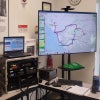
Looks like my PiAware is up and running, so that's a good milestone. I still have work to do but I'll enjoy the buzz of mild success for now! Also it's cool that my Pi shows the NEXRAD weather radar on the map at the same time as well.

  • All
  • Subscribed
  • Moderated
  • Favorites
  • adsb
  • tacticalgear
  • DreamBathrooms
  • khanakhh
  • mdbf
  • InstantRegret
  • magazineikmin
  • everett
  • cubers
  • rosin
  • Youngstown
  • slotface
  • ngwrru68w68
  • kavyap
  • thenastyranch
  • JUstTest
  • modclub
  • Durango
  • GTA5RPClips
  • cisconetworking
  • osvaldo12
  • ethstaker
  • Leos
  • tester
  • anitta
  • normalnudes
  • provamag3
  • megavids
  • lostlight
  • All magazines