blueghost,
@blueghost@mastodon.online avatar

OpenStreetMap supports mapping surveillance cameras.

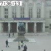
Cameras can be identified by location and type, the area being observed can be disclosed.

Surveillance under Surveillance/https://sunders.uber.space is an OpenStreetMap instance focused on surveillance cameras, it uses data that is not visualized on the OpenStreetMap.org instance.

Website: https://www.openstreetmap.org
Mastodon: @openstreetmap

image/png
image/png
image/png

  • All
  • Subscribed
  • Moderated
  • Favorites
  • privacy
  • rosin
  • ngwrru68w68
  • thenastyranch
  • magazineikmin
  • hgfsjryuu7
  • DreamBathrooms
  • Youngstown
  • slotface
  • vwfavf
  • PowerRangers
  • everett
  • kavyap
  • Durango
  • khanakhh
  • anitta
  • tacticalgear
  • InstantRegret
  • cubers
  • mdbf
  • ethstaker
  • osvaldo12
  • GTA5RPClips
  • cisconetworking
  • tester
  • normalnudes
  • modclub
  • Leos
  • provamag3
  • All magazines